
Where Does Route 66 Start And End? | Everything You Need To Know – USA
Disclosure: This posts may contain affiliate links. I may make a small commission on purchases made after clicking the link. I do my best to try and keep information up-to-date but please check direct with businesses for current opening times and prices. For more information visit the Privacy & Disclosure Policy. Thank you for your support!
Route 66 is the 2448 mile road trip that travels through 8 US states: Illinois, Missouri, Kansas, Oklahoma, Texas, New Mexico, Arizona and California. But where does Route 66 start and end? The quick answer is that the beginning of Route 66 is in Chicago and end of Route 66 is in Santa Monica, Los Angeles. However, in this post I go in to depths about the official and unofficial Route 66 beginning and end points!
In This Guide
Where Does Route 66 Start in Chicago
Official Route 66 Start
📍E Jackson Drive and S Lake Shore Dr, Chicago, Illinois
The official Route 66 starting point (and end point for eastbound travellers) is at Jackson Blvd and Michigan Ave. This is as close to the shores of Lake Michigan as you can get and has been the start/finish point of Route 66 since 1937. Although nothing special marks this location.
If you’re looking for a photo opportunity, it’s best to head the the unofficial Route 66 start.
Unofficial Route 66 Start In Chicago
Route 66 Start Sign
📍E Adams St and S Michigan Ave, Chicago, Illinois
Part of Jackson Blvd is a one-way system. When the route reaches Michigan Avenue, it heads north for one block, before continuing east along E Adams St. Set slightly back from the corner of where E Adams St and S Michigan Ave meet, is the Route 66 BEGIN sign.
Unfortunately, groups have started covering the signs with stickers. So sometimes the ‘Begin’ part of the sign is actually covered up. It did get replaced a while back, but there’s no guarantee that the sign will be fully visible.
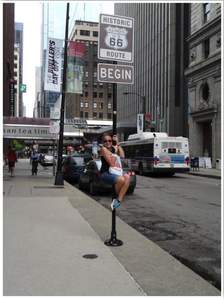
There’s a second ‘Historic Route Begins’ sign, on the corner of S Wabash Ave and E Adams St. Again, this one is covered in stickers too, and is located in a small park area. Route 66 signs are then found intermittently along E Adams St.

Route 66 End Sign in Chicago (East Bound Travelers)
📍E Jackson Blvd and S Michigan Ave, Chicago, Illinois
Historically the route travels westbound between Chicago and Los Angeles. It was the main route for people migrating to the western USA during the Dust Bowl period in the 1930s. In the present day, some travellers choose to do the route in the reverse direction between Los Angeles and Chicago.
For eastbound travellers, there is a Route 66 end sign in Chicago. This is located along E Jackson Blvd and S Michigan Ave, a short distance away from the official ending.
Related reading: Route 66 Chicago: A Guide To The Start of Route 66 & 2 Days In Chicago!
Where Does Route 66 End?
Official Route 66 End
📍Lincoln Blvd and Olympic Blvd, Los Angeles, California
Just like the official beginning of Route 66, the endpoint in LA is similarly not marked. Instead, a short drive away is the unofficial ending at Santa Monica Pier.
Unofficial Route 66 End In LA
Route 66 End Sign
📍Route 66 End of the Trail Marker, Santa Monica Pier, LA, California
The Route 66 ‘End of the Trail’ marker can not be driven to or past. It’s located on the pedestrianised area of Santa Monica Pier. So you’ll have to park up and then walk the final stretch to the end sign. There’s a small souvenir stall next to it too, for some last-minute Route 66 merchandise!

📍Palisades Park, Ocean Ave, Santa Monica, LA, California
A short walk from the iconic Santa Monica Pier arch in Palisades Park, is the Will Rogers Highway marker. This is another unofficial end of Route 66.
Route 66 is sometimes referred to as the ‘Will Rogers Highway’. Will Rogers was a famous American actor and writer who travelled part of the route in the 1890s. In 1928 he covered a story in a newspaper column, about a race that took place along Route 66. This coverage put Route 66 in the public eye.

Route 66 Midpoint
📍Adrian, Texas
The midpoint of Route 66 is in Adrian, Texas. It’s exactly 1139 miles from Chicago and 1139 miles from Los Angeles. There’s a sign/photo opportunity showing the midpoint, located opposite the Midpoint Cafe.

Where Does Route 66 Start and End FAQs
As you can see there are a couple of options for start and end points. Being tourists on the route, we decided the unofficial beginning and finish points were enough for us. After all the signs make for fun photo opportunities!
Where does Route 66 start and end how long does it take?
The quick answer: Route 66 starts in Chicago, Illinois and ends in Los Angeles, California. For my trip, the total drive time was 85 hours (including roadside attractions and photo stops).


About the Author – Kylie
My travels have taken me to over 50 countries worldwide (& I lived in USA for 4yrs). I hold a BTEC National Diploma in Travel & Tourism (triple distinction) and have been writing on Between England & Everywhere since 2015.
Expert in: Adventure travel🎢, beach destinations🏖️, and packing light (mid-budget backpacker)🎒
Found this post useful? Pin it for later!

Love the Rt 66. I’ve driven most of “what’s left” in Illinois and Missouri. Still some very cool spots to see though.
Agreed! I actually have a post scheduled in a few weeks time about the Illinois stretch! I wish I had spent longer as we tried to squash it all in to one day! (Not including seeing Chicago)
The best road trip I’ve ever taken. Bar none.
Agreed!